|
|
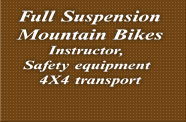
EQUIPMENT PROVIDED for all trips:
FULL SUSPENSION MOUNTAIN BIKE, helmet,
gloves, knee and elbow pads,chest protector, Bike Top
PROVISIONS PROVIDED for all trips:
1 liter water , LUNCH at destination
WHAT TO WEAR:
Shorts and shirt, sport shoes, extra shirt and shorts Light
rain coat in rainy season .
WHAT TO BRING:
plastic to protect camera etc. day pack ( we have one for
you if you don't have one) |

Fully
guided climb up to Doi Pui National Park summit. From here
after a long deserved lunch break at the Hmong village (1400m
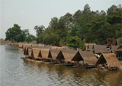
elev.) we descend by bike down to lake Huay Tung Thao.
|
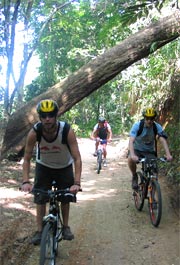
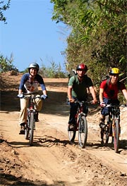
TRIP
DESCRIPTION HIKE UPHILL - RIDE DOWNHILL
|
|
| When: |
9:30 am-3:30 pm. All year rain or shine
|
| Trip: |
Suthep National Park |
| Location: |
Mountain 5400 feet elevation , above Chiang Mai |
| Biking time: |
Hiking: 2.5 hrs, Biking: 1-2 hrs > 25 km |
| Elevation change: |
4000 feet (1300 m) |
| Riding Conditions: |
50% uphill trekking, 50% downhill off road riding |
| Flora: |
Lowland jungle, highland pine forest |
| Levels: |
Beginner/Intermediate |
| Personal fitness: |
Above average |
| Instructions: |
Yes |
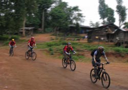
Hike & Bike 1 Day
 
Hike & Bike 2 Days
|
|
| |

A
lengthy uphill ride along the lush northeast side of Suthep
National Park brings us to the Hmong village to spend the night
and ride down the following day to Lake Huay Tung Thao.
|
TRIP DESCRIPTION
OFF ROAD 1 DAY UPHILL - 1 DAY DOWNHILL
|
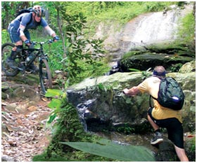
 Our
4 wheel drive transportation takes us to the north west end
of Doi Pui Mountain From here we start our lengthy climb up
to Doi Pui mtn. The gradual climb brings us to the divide
where we drop deep into a highland jungle gully between two
mountains. At 3200 feet elevation we notice the tropical forest
emerging from the pine woods, with huge banana leaves and
plenty of bamboo filtering the light. Our
4 wheel drive transportation takes us to the north west end
of Doi Pui Mountain From here we start our lengthy climb up
to Doi Pui mtn. The gradual climb brings us to the divide
where we drop deep into a highland jungle gully between two
mountains. At 3200 feet elevation we notice the tropical forest
emerging from the pine woods, with huge banana leaves and
plenty of bamboo filtering the light.
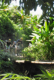
Once at the bottom of the gully we begin a long and rewarding
uphill back to 3800 feet, some ride, some walk, concentrating
and preserving energy on the way to our summit.
We Continue to climbing the road up to the hill tribe village
at the end of the forest trail
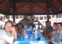
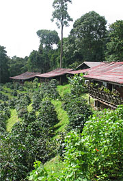
Once at the Mong village we enjoy a late lunch/early dinner
under the watchfully eyes of the village kids. Here we spend
the night and refresh our senses with the cool mountain air.
The next morning after breakfast we prepare for an relaxing
and scenic day riding down to Huay Tung Thao lake where a
well deserved lunch awaits us.

|
| When: |
Daily 9:30 am-4:30 pm. All year rain or
shine |
| Trip: |
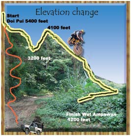
Doi Pui to Maesa Valley |
| Location: |
Mountain 5400 feet elevation, above Chiang Mai |
| Biking time: |
Approx: 4 hrs, 35 km |
| Elevation change: |
From 5400 feet (1600 m) down to 3200(1100 m) up to 4100
feet and down to 1200 feet (400 m) |
| Riding Conditions: |
75% downhill, rarely used dirt road |
| Flora: |
Pine forest, jungle, plantations |
| Levels: |
Motivated beginners through experts |
| Personal fitness: |
Good |
| Instructions: |
Yes |
| |
|
| |

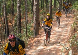
After
a rewarding day of riding to the top of Pakia Mnt. (1750m) with
incredible views of the Chiang Dao Mountain range, we spend
the night at the summit in comfort to descend the next day into
Mae Taman Valley / Mae Taeng Valley. |
TRIP DESCRIPTION
OFF ROAD 1 DAY UPHILL - 1 DAY DOWNHILL
|
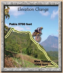 A
short 1 hr drive takes us to the base of 5700 foot high Pakia
mountain right next to the famous Doi Chiang Dao mountain
range "The last tooth of the Himalayas". This well shaded
uphill bike ride to Pakia Summit becomes more and more rewarding
as we approach the top with its breath taking views of Doi
Chiang Dao. We spend a peace full night in the cool air of
Pakia mountain. The following day we cruise one of the many
trails down the mountain depending your skill level. This
is a truly remarkable experience and is reserved for the fit
nature buff. A
short 1 hr drive takes us to the base of 5700 foot high Pakia
mountain right next to the famous Doi Chiang Dao mountain
range "The last tooth of the Himalayas". This well shaded
uphill bike ride to Pakia Summit becomes more and more rewarding
as we approach the top with its breath taking views of Doi
Chiang Dao. We spend a peace full night in the cool air of
Pakia mountain. The following day we cruise one of the many
trails down the mountain depending your skill level. This
is a truly remarkable experience and is reserved for the fit
nature buff.
|
| When: |
8:30 am-5:30 pm |
| Trip: |
1 st day ride up to Pakia Summit . 2nd day descent
to Mae Taeng Valley |
| Location: |
Mountain 5700 feet elevation near Chiang Dao |
| Biking time: |
uphill approx: 5 hrs, 25 km, DH approx: 3-4 hrs : 35
km-45km |
| Elevation change : |
from 5700 feet (1700m) down to 1300 feet (450m) |
| Riding Conditions: |
1 st day 90 % uphill and 2nd day 90% downhill, rarely
used dirt road |
| Flora: |
Pine forest, jungle, plantations |
| Levels: |
intermediate through experts |
| Personal fitness : |
above average |
| Instructions: |
Yes (I hope not) |
| |
|
|
| |
|